Distance Learning Modules from University of Nebraska Omaha
DLM 1 The Hydrologic Cycle
The whole text of the DLM1
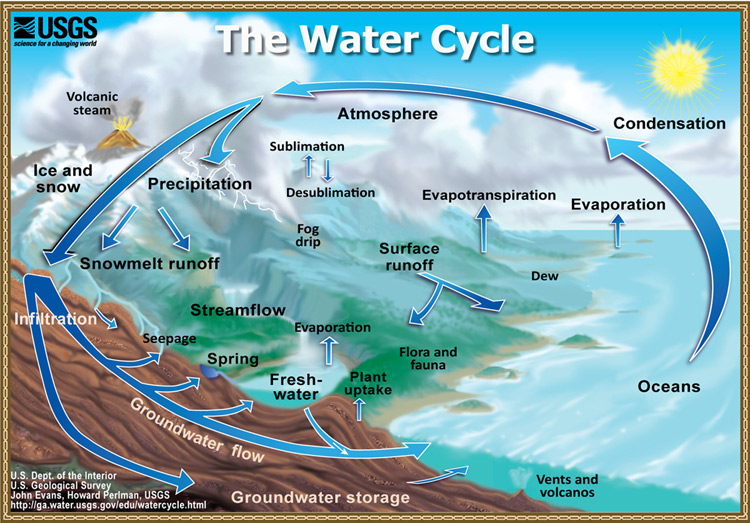
Figure 1.The hydrologic (water) cycle of the world (in English) (from US Geological Survey)
DLM 2 - The Hydrologic Cycle in Southwest Asia
The whole text of the DLM2
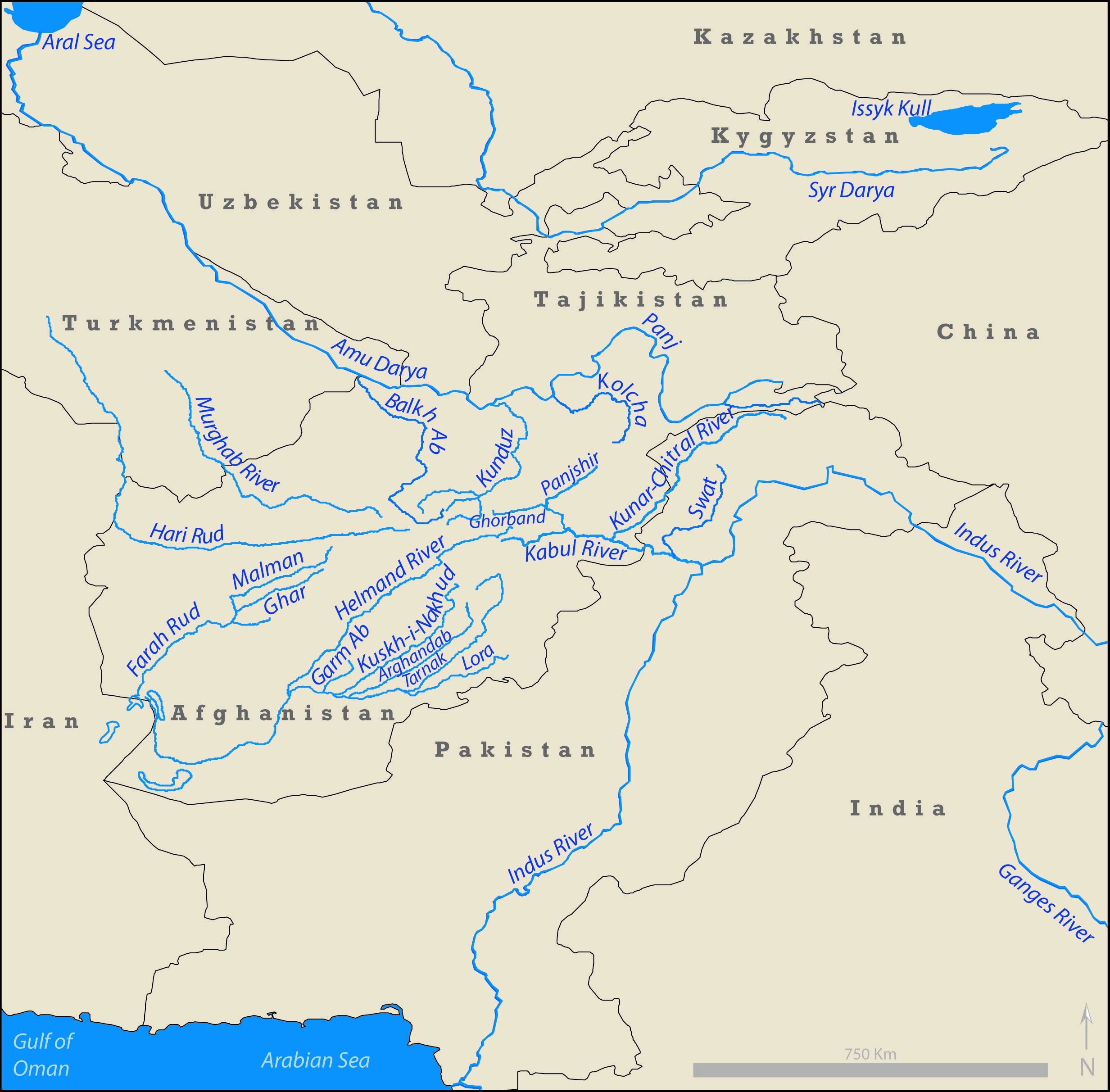
Figure 2. Maps of the drainages of the (A) Indus River and the (B) Kabul River tributary to the Indus.
DLM 3 Rivers of the Hindu Kush, Pamir, and Hindu Raj
The whole text of the DLM3
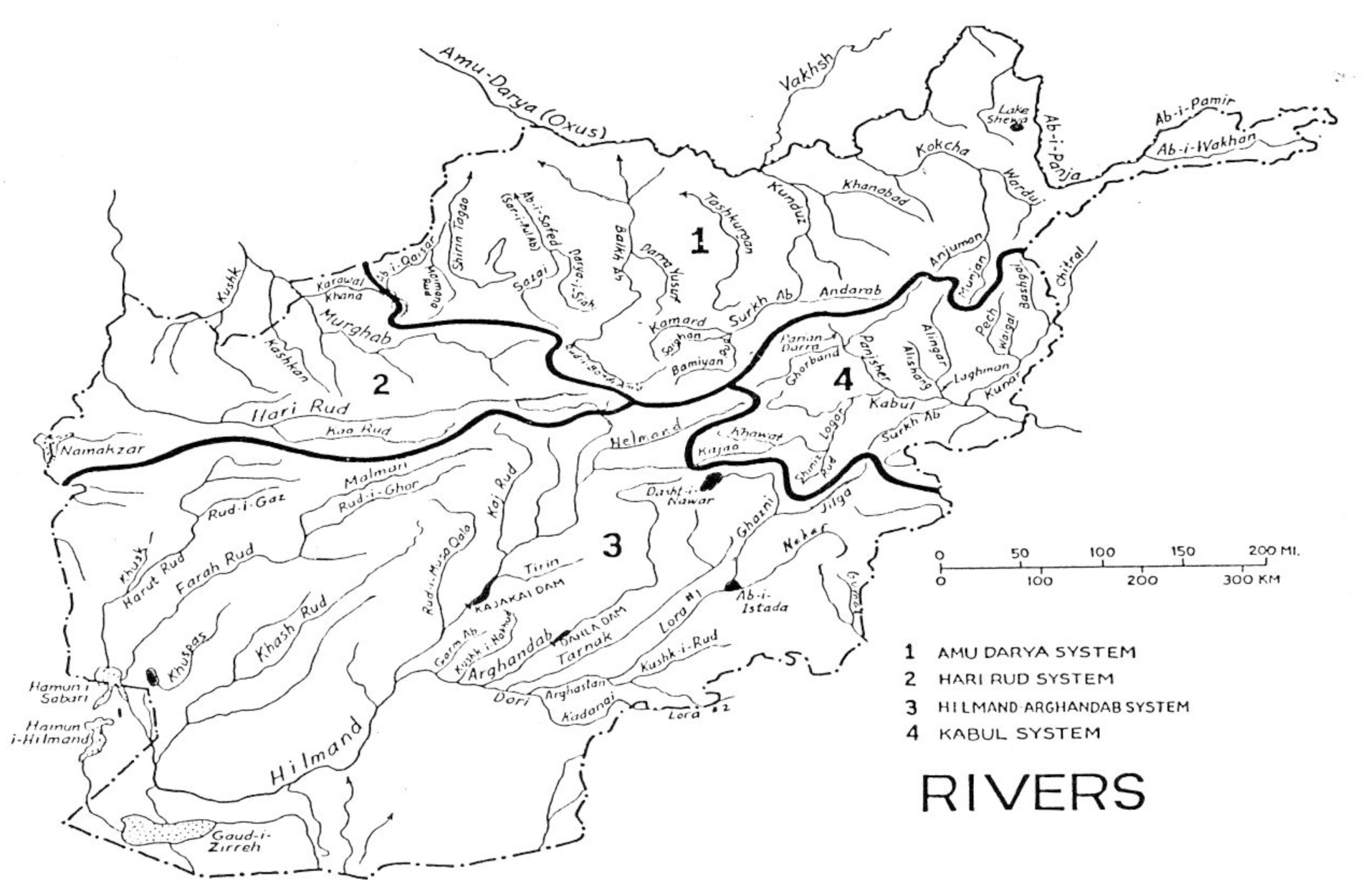
Figure 3. Map of the main rivers of Afghanistan
DLM 4 Afghanistan Lakes
The whole text of the DLM4
Lakes in Afghanistan are not common in most parts but are most important for providing water for people, animals, and for providing freshwater recharge that soaks down into the underground aquifers where tube wells and karez irrigation can be used to get the good water (Figure 3 from DML 3).
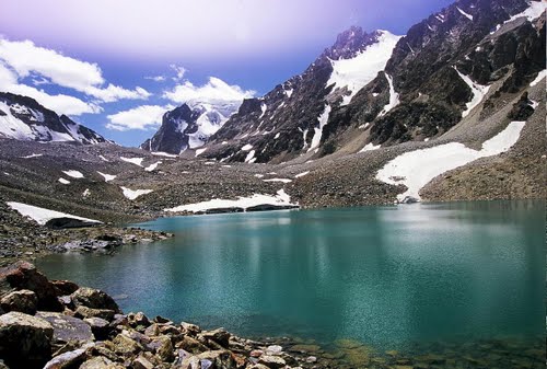
Figure 4. Glacial lake in the Wakhan Corridor where the ancient ice melted away and left behind a lake in the rock basin that was eroded by the ice originally.
DLM 5 Measuring Water
The whole text of the DLM5
Water Volume Measures and Water Accounting
- Volumes of water are measured in cubic meters (m3) or cubic kilometers (km3).
- Flowing volumes of water are measured in cubic meters or cubic km per second (km3/sec).
- One cubic km of water equals one billion cubic meters (bcm) – (1km3 = 1 BCM).
- Traditional measures of water flow have been calculated by measuring the channel width (in m) and channel depth (in m), together with the water-flow velocity (in m/sec) to give the water-flow volume when multiplied together (m3/sec).
- Many rivers have a known measured width and depth at certain places where the velocity can be measured periodically to obtain average river-water discharge (m3/sec).
- In the 1950s – 1970s, the US Geological Survey (USGS) and the Afghanistan Geological Survey (AGS) built weirs or places on the river banks of Afghanistan to measure river discharge but most were destroyed after the Soviet invasion in 1979.
- Since 2002, many new discharge stations have been re-erected all over Afghanistan to gather river water discharges again (Figure 5).
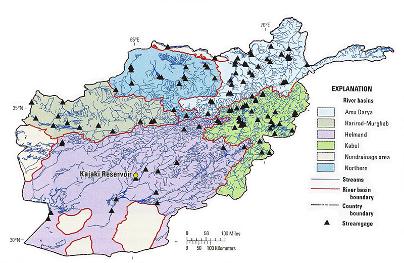
Figure 5. Map of the new stream gauges installed in Afghanistan by the Afghanistan Geological Survey (AGS) and the US Geological Survey.
DLM6 - Climate Change Implications in Central and South Asia
The whole text of the DLM6
World climates have been noticeably changing in recent years as industrialization and agriculture have added ever more carbon dioxide (CO2) and methane (CH4) gases into the atmosphere. Such greenhouse gases allow sunlight heat energy to penetrate through the atmosphere but not to go back out again so the heat builds up. As the Earth warms up, the glaciers melt away and the warmer air increases evaporation of water on the ground – the result is increased droughts, and loss of river and lake water. Increased droughts and greater water usage by humans is expected to cause ever more problems. Such problems have caused many disruptions and violence (Figure 6)
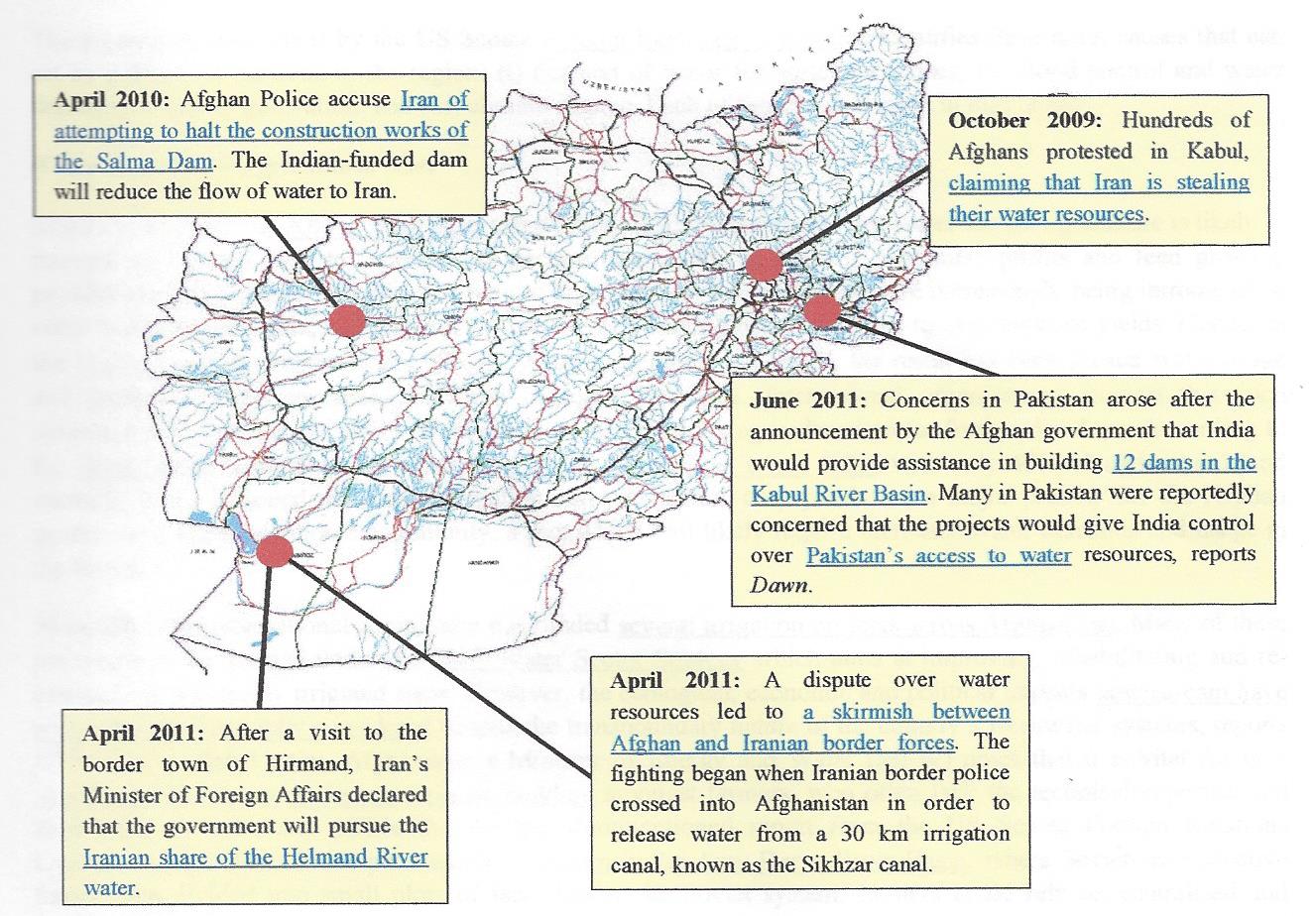
Figure 6. Map of Afghanistan showing numerous problems with water shortages caused by climate change. Dams are an effort to save more water upstream to help Afghans. This causes problems downstream in Pakistan and Iran.
DLM 7 - Transboundary Resource Management
The whole text of the DLM7
MANAGEMENT OF WATER FLOW
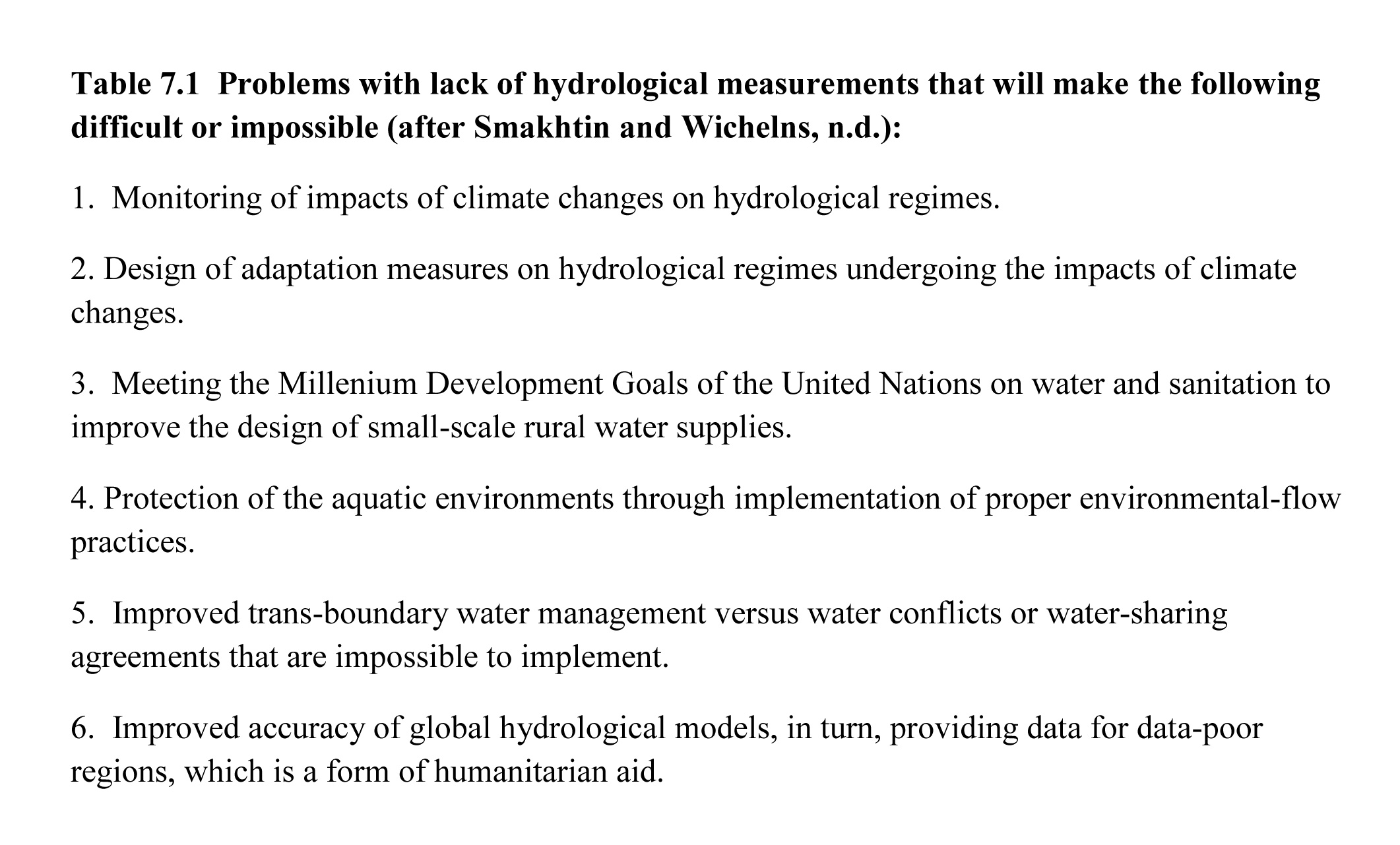
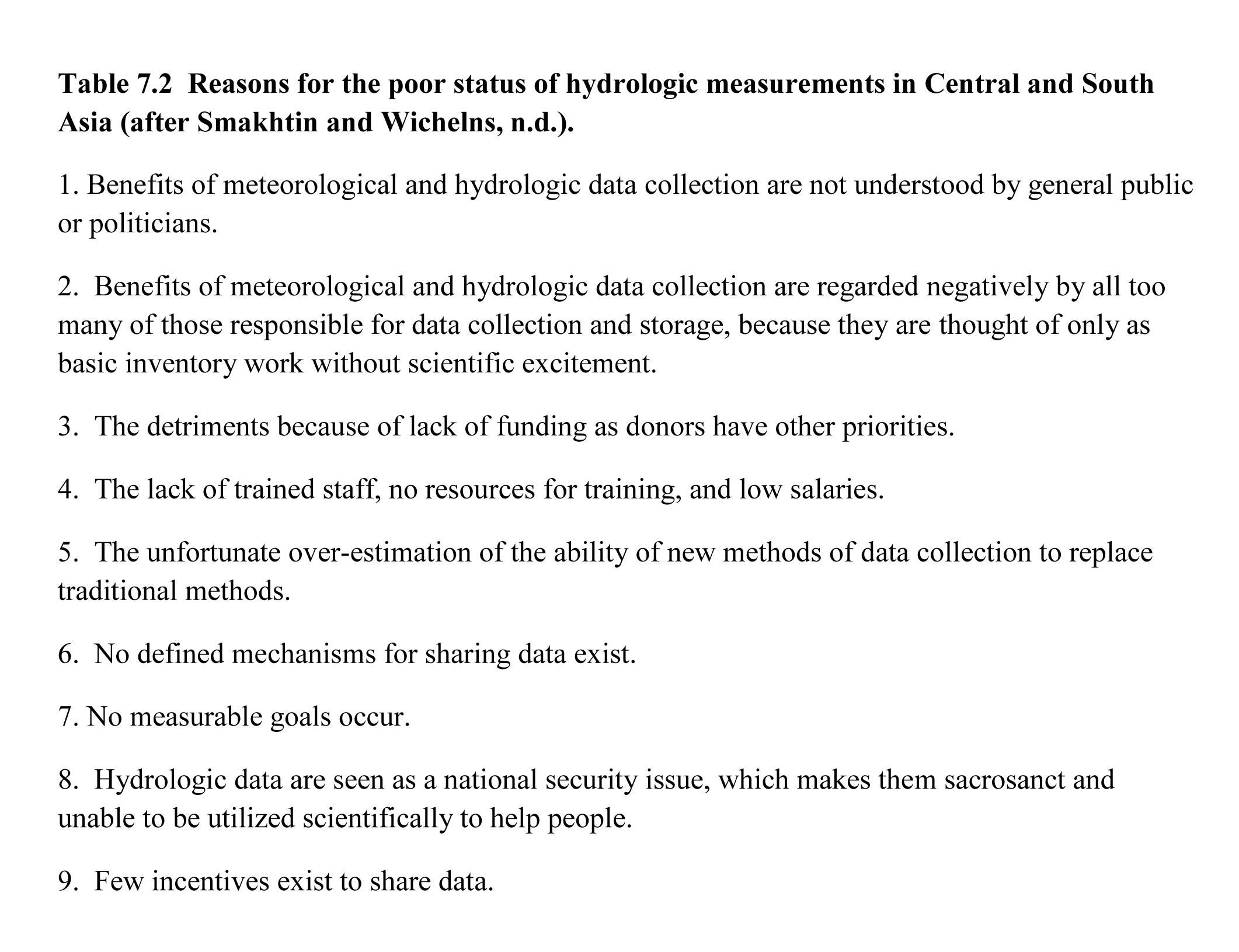
The flow of river waters must be managed and channeled into appropriate channels for the benefit of all the different stakeholders (Tables 7.1, 7.2).
DLM 8 - Floods and Natural Hazard Management
The whole text of the DLM8
DEALING WITH WATER-RELATED NATURAL HAZARDS
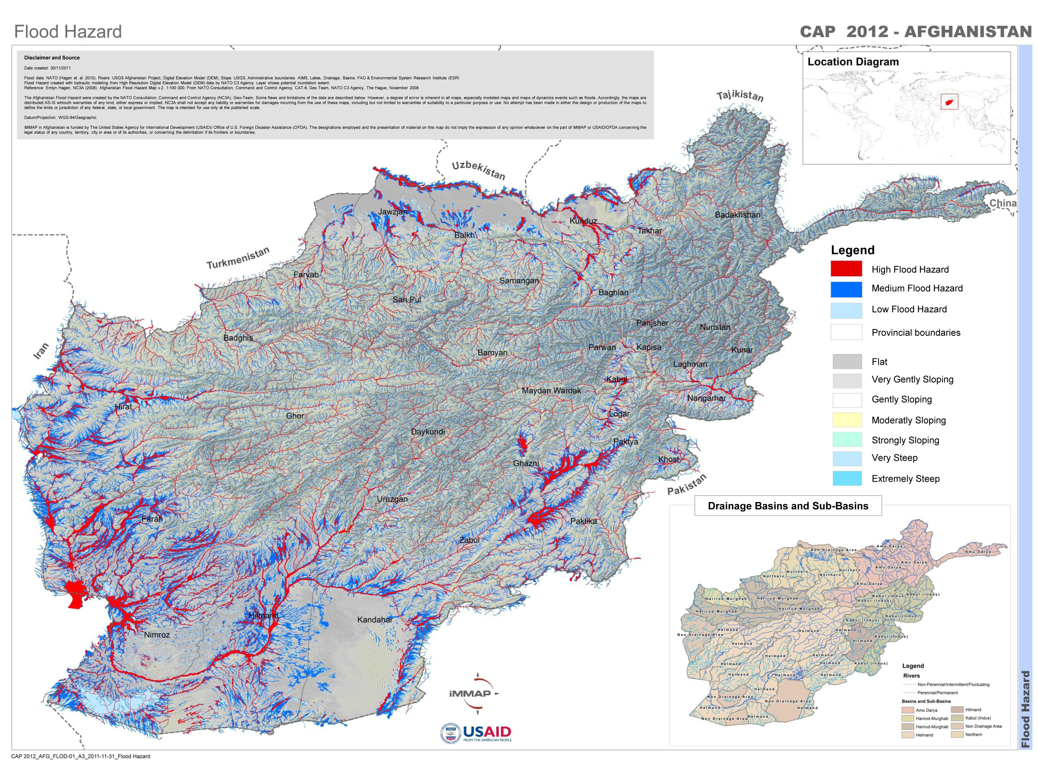
Figure 8. Flood hazard map of Afghanistan derived from the Afghanistan flood hazard map (AFG-FHM) of Hagen et al. (2010) The map on line is capable of considerable enlargement, although the original could generally be accurately enlarged to 1:100,000. Red indicates high flood hazard and dark blue is moderate flood hazard.
DLM 9 - Market Mechanisms for Water Sharing
The whole text of the DLM9
- Downstream nations almost always have wide floodplains and rich deltas into the seas where civilizations began thousands of years ago and major development has occurred there over long periods of time.
- Downstream countries, because they are more developed, tend to have greater skill with engineering than upstream nations with more limited development.
- Upstream nations are the headwaters in mountains where development has lagged behind.
- Water delivered from an upstream nation to a downstream nation is a vital, valuable commodity.
- Potential exists for financial rewards for water deliveries downstream (the current term is PES – payments for ecosystem services).
DLM 10 - Water Law and Water Treaties
The whole text of the DLM10
Afghanistan has no water treaties with any neighboring countries because all old treaties were signed with political entities that no longer exist (British Raj of India, Shah of Iran, USSR).
The Government of Afghanistan is itself a new government with no prior water treaties.
DLM 11 - River Dams
The whole text of the DLM11
Improvement/development of water-resource infrastructure in Afghanistan is driven by optimistic return from 30 years of constant war & damage/destruction of prior infrastructure from 1940s – 1970s.
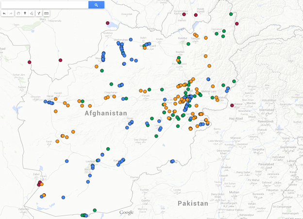
Figure 9. Dams/Diversions/Planned Dams in Afghanistan (green dots-existing, orange-proposed, green-diversions, and red-conterminous dams).
DLM 12 - Kabul-Kunar River Hydropower & Irriggation
The whole text of the DLM12
The Kabul River Basin has a drainage area of about 54,000 km2, which is only about 12 % of the land area of Afghanistan but about 26% of the annual flow of the country. It flows along or through borders of 11 provinces with a population of >7 M people. The Kabul River discharge water volume generally ranges 33 – 460 m3/second but in recent drought years has run dry in Kabul City. Lower Kabul River near Pakistan border can go 700 m3/second (22 km3/year). The Kabul River has its main upper tributaries being the Logar River, and the Panshir River that has the major Ghorband tributary. Logar River is tributary to Kabul River near Kabul City, but does not have a large discharge and much of its water is used in irrigation.
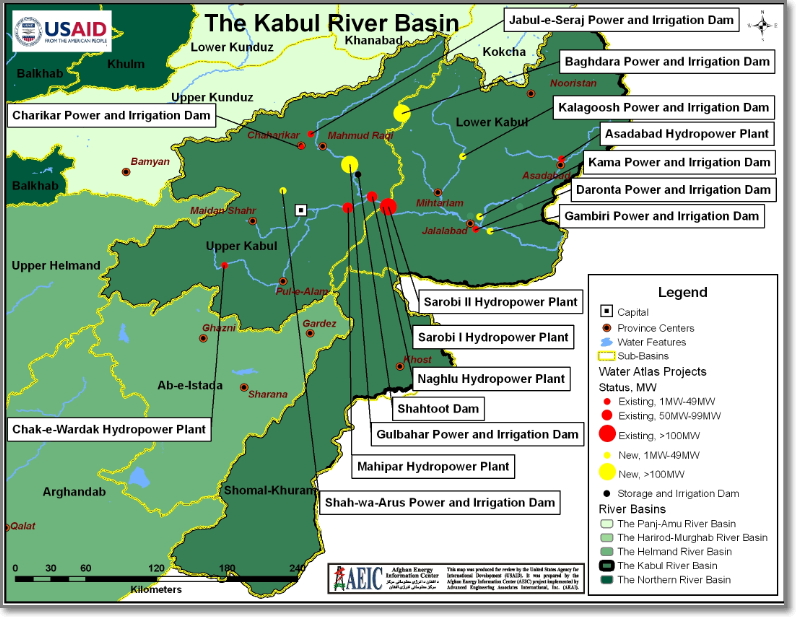
Figure 10. Map of water projects past, present, and planned on the Kabul River and its tributaries. This map is incomplete in terms of all the tributaries (Ghorband River is missing; tributary names are missing).
DLM 13 - Panj and Amu Darya River Hydropower and Irrigation
The whole text of the DLM13
Data about water in the Panj (Pyanj) and Amu Darya river systems are highly variable from wet to dry years so they must be judged carefully, but some generalizations are possible.
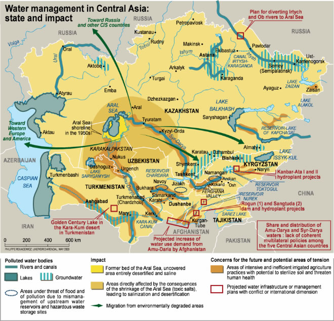
Figure 11. Water management in Central Asia, state and impact.
DLM 14 - Helmand River and Hari Rud-Murghab Hydropower and Irrigation
The whole text of the DLM14
The Helmand River Basin in Afghanistan is 43% of the total surface area in the country.
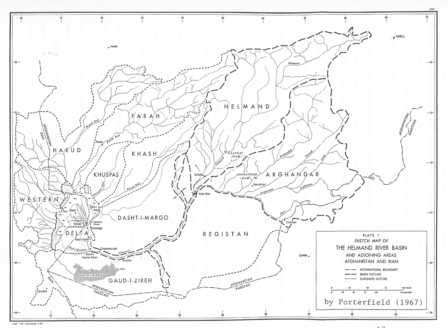
Figure 12. Details of the Helmand River basin.
DLM 15 - Afghanistan Ground Water Issues
The whole text of the DLM15
Water underground occurs in areas dominated by sediments (mud, clay, silt, sand, gravel) and sedimentary rocks (shale, sandstone, conglomerate, limestone).
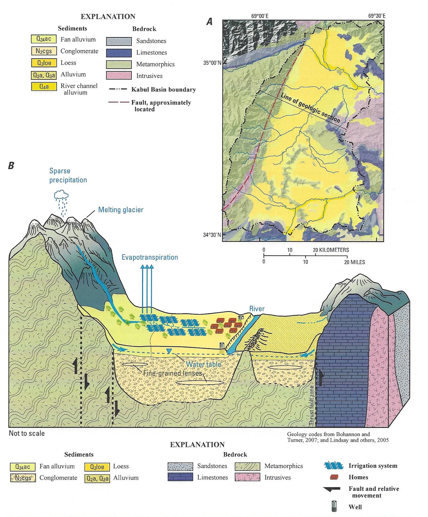
Figure 13. Drawing of the ground-water basin of Kabul.
DLM 16 - Hydro-Capacity Building
The whole text of the DLM16
BEST CAPACITY BUILDING AND TRAINING IN WATER ISSUES
- Define precisely what is meant by capacity building (on-the-job training, laboratory work, office work, university education, remedial education, etc.).
- Build the capacity of local officials, technicians, and scientists so that they can monitor, assess, and manage the water resources of the country.
- Use the Distance Learning Modules provided by the Afghanistan Studies Center from the University of Nebraska at Omaha (UNO) for some remedial and exploratory assessment to learn new things about water, as well as to find out what is needed.
DLM 17 - International Water Information Sharing & Construction of Upstream International Partnerships with DownstreamWater Desires
The whole text of the DLM17
Information Sharing
- International water management requires access to the best new data and information available.
- Such information can be developed by classical field measurement of precipitation, river flow volumes, and such, which are best done by local personnel.
- Measurement of precipitation, snow-water equivalent, river flow, soil moisture, and other measures of weather and climate, and water availability can be obtained with satellite remote sensing.
- Maintenance of robust records of water flows is essential to good water management, especially in times of unforeseen climate change.
- The Transboundary Water Website maintained by the University of Nebraska at Omaha is the best site available to store hydrological water data at no charge to the permitted officials of the governments of Afghanistan, Tajikistan, and Pakistan.
DLM 18 - Glacier Inventory
The whole text of the DLM18
Glacier inventory is the mapping and measuring of all the glaciers (frozen H2O) in the mountains of a country.
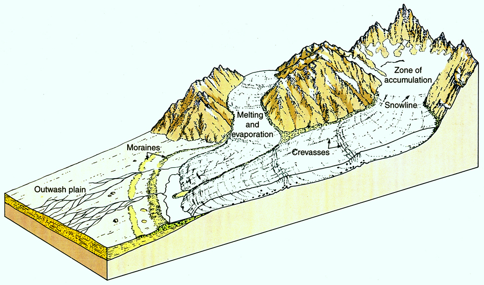
Figure 14. Glaciers accumulate in high mountain areas and then slide and flow down to lower elevations where they melt away in the lower ablation zone.
DLM 19 - Access to High Technology to Study Water with Grant-Funding Partnerships
The whole text of the DLM19
- Afghanistan and Tajikistan lack the technological and monetary means to study many of their water issues.
- Pakistan is in a better educational and financial position to study its water issues but does lack motivation or some access to the higher technologies.
- The technological means to study water issues in Central and Southwest Asia are available to personnel from International Studies at the University of Nebraska at Omaha UNO and our international Dougherty Water for Food Institute (DWFI).
DLM 20 - Hydro-Hegemony (National Power Over Water)
The whole text of the DLM20
- Hydro-hegemony is the four systems by which any country measures and controls the waters in its own territory.
- Geography power is locational position in the headwaters or downstream on any given river system.
- Material power is based on population, literacy, military strength, infrastructure, and any materials attributes a country enjoys as an internal standard of living.
- Bargaining power is about knowing the rules of water and diplomatic negotiations.
- Ideational power is the power of new ideas about water, and new ways of thinking about water problems.
- Hydro-hegemony is a semi-quantitative assessment of the strength by which any country can think to manage its water resources to a maximum of efficiency and beneficial use.
- Afghanistan has five major river systems (Kabul, Helmand, Harirud – Tenjen – Murghab, and Amu Darya), all with many tributaries that flow out to neighboring countries.
- In part because of poor management, several of these large rivers have dried up recently before crossing the borders into adjacent districts.
- Some maneuvers have been made by regional nation-states to maximize control of the water resources in whatever ways possible.
- Afghanistan and Tajikistan, positioned at the top of the watersheds, are in otherwise enviable positions, providing that their mutual hydro-cognizant capacities can be raised sufficiently and swiftly enough, before too much opposition rises to the fair use of their waters.
- Raising of hydro-cognizant capacities is necessary before entering into eventual negotiations with all the neighbors about water.