GNSS Geodesy Polygon
Nazarbayev University, a modern and rapidly developing university in the Republic of Kazakhstan, which was founded in 2010. For the preparation of engineers in the field of construction, geological exploration, cartography, mining, within the framework of a grant from the Royal Engineering Academy in the territory of Nazarbayev University a geodetic testing site (GNSS Geodesy Polygon) was established. The geodesic test site allows you to carry out a range of scientific and technical tasks to clarify the parameters and measurements of the global gravitational model of the Earth and to conduct practical training for students, undergraduates and other stakeholders on modern geodetic instruments to identify coordinate reference systems and their application in various fields of engineering.
The following activities are carried out at the geodetic site:
- building a model of the gravimetric field of the Earth and studying changes in the gravitational field in local regions to clarify the parameters of the global gravitational model of the Earth;
- Metrological certification or calibration of geodetic instruments; testing of instruments;
- Research and improvement of geodetic technologies and methods: satellite geodetic measurements, ground topographic surveys, digital geometric leveling; optimization of creating special geodetic systems
- Conducting training activities for the training of personnel and the development of new instruments and measurement technologies.
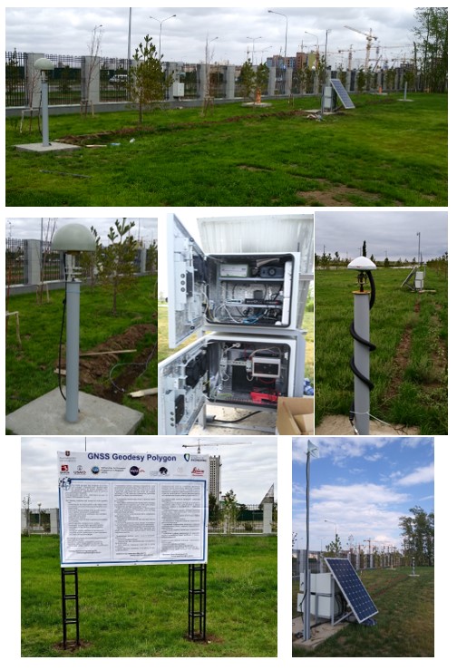
The geodesic polygon is equipped with the following elements:
- linear basis;
- the stand for research of theodolites and levels;
- Leica base station (GNSS antenna Leica AR-10);
- JAVAD base station (GNSS antenna Ring Ant-Dm);
- geodesic equipment.
More info on the GNSS Geodesy Polygon: https://drive.google.com/file/d/1JgotkKu94r0afrcEmBNib7BPKzhU-SUL/view?usp=sharing