iRIC Software Nays2D Flood
What is the iRIC Software?
iRICXXX (International River Interface Cooperative) is a river flow and riverbed variation analysis software package which combines the functionality of MD_SWMS, developed by the USGS (U.S. Geological Survey) and RIC-Nays, developed by the Foundation of Hokkaido River Disaster Prevention Research Center.
The amalgamation of these pieces of software was proposed by Professor Yasuyuki Shimizu (Hokkaido University) and Dr. Jon Nelson (USGS), bringing together the accumulated analysis technology and software developments of MD_SWMS and RIC-Nays. Our vision is to continue to work on cutting-edge technology, incorporating the requests and opinions of our users to develop and provide even more useful software. We ask for your kind support in developing the most useful software possible.
Following is an outline of the iRIC software, its functions, and features.
iRIC Software Outline/ Features
The iRIC software consists of three functions: preprocessor, postprocessor, and solver.
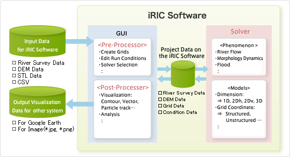
Blow is the link to outline of each functions and features: